Looking for a dedicated GPS chartplotter for your boat? The Garmin GPSMAP 740 and 740S are designed specifically for that but how do they stack up in terms of features, design, price to value, and performance? That’s what we’re here to find out.
Introduction
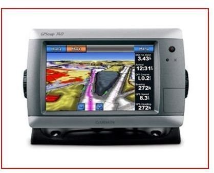
The Garmin GPSMAP 740 is a marine GPS/chartplotter device geared toward boaters. This model is a stand-alone chartplotter, which means it’s strictly a navigation aid designed to help you chart a course and pilot your vessel safely no matter where you want to go on the coastal waters of the US and the Bahamas. The basic version of this device can be expanded upon if you want to add other Garmin radar and weather units. The 740S version is compatible and ready for the additional BlueChart Vision G2, sonar, or audio weather units later too. The 740S model comes with a built-in fishfinder, so that would be the best choice for avid anglers. Compared to the top-of-the-line Furuno chartplotters , the GPSMAP 740 is relatively expensive but still a good performer despite lacking many of the built-in capabilities those other models have.
Image courtesy of amazon.com
Design (5 out of 5)
You can count on Garmin chartplotters to withstand the very exacting conditions of rugged sea life. It’s waterproof and durable so long as you don’t miss a fish with a mighty swing of your gaff and hit the GPSMAP 740 instead. But it’s designed to be left out in the open if you don’t have a pilot house. As far as size, the whole unit is 8.8" x 5.6" x 3.1" which is not going to take up a lot of room on your console and leaves room to expand with the other compatible accoutrements mentioned above as you see fit. The antenna is internal.
Features (4 out of 5)
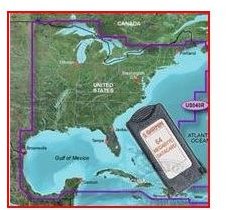
The Garmin GPSMAP 740 has a high resolution touchscreen that measures 6.0" x 3.6" which isn’t that big but it’s highly viewable in all conditions. It’s listed everywhere as a 7" inch display but that’s actually the diagonal. The GPSMAP 740 has pre-loaded Garmin GPS marine maps , including detailed Garmin BlueChart maps for the coastal US (which have Alaska and Hawaii) and Explorer charts for the Bahamas. The incorporated Garmin BlueChart G2 information will display detailed coastlines, shaded depth contours, navaids, port plans, wrecks, tide, moon, and current information, along with restricted areas to.
Image courtesy of amazon.com
Ease of Use (5 out of 5)
The user interface is simple, especially since it’s a touchscreen which means most of the commands are right there for you to see without having to navigate through many dropdown menus. Anytime you want to edit a waypoint, route or track, the screen automatically becomes a keyboard which is so much faster than the tedious process older models used. The commands are similar, but also streamlined, to other Garmin GPS units which makes it a breeze if you’ve ever owned a Garmin GPS before.
Performance (4 out of 5)
The Garmin GPSMAP 740’s redraw rate is super-fast and you can easily scroll around charts to look at other areas. The aerial photos are a really sharp enhancement and you’ve got 3D viewing capabilities, although you need to buy the additional BlueChart G2 Vision card which will also give you audio guidance as well. By adding Garmin’s G2 Vision card you’ll also get fishing charts, auto-guidance, 3D mariner eye views and 3D fish eye views (it’s definitely worth getting because it really enhances performance). All the maps are loaded through the SD card slot which means you can add any map you want beyond the preloaded coastal maps you get. But there is no internal memory, so don’t forget the SD cards.
The touchscreen is durable, like it should be, for the rugged conditions and use it will get, even with gloves on. Switch from monitoring information you called up on the screen to plotting on the digital marine navigational chart almost instantaneously and intuitively. The high sensitivity GPS receiver tracks your position and the chart redraws accurately at high speeds. The ability to dim and brighten the display to adjust to natural light conditions is easy on your eyes too.
What’s Included? (4 out of 5)
Out of the box you get top and bottom snap covers, a bail mount with built-in cable management so you don’t have a wiry mess, a mount with the hardware to put the Garmin GPSMAP 740 in place, a threaded power/data cable, a protective cover, knobs, and the documentation.
Price to Value (4 out of 5)
The Garmin GPSMAP 740 lists for $1499 on Garmin’s official website which is about what you’ll find it for elsewhere. Currently, the enhanced GPSMAP 740S is available at amazon.com for $1700. For a model of this size with all of those features, the GPSMAP 740 is a really good deal especially with how easy it is to add on. Other models, especially the ones with larger displays, will cost you a lot more. But by way of comparison, be sure and check out top chartplotter reviews and recommendations to see the top of the line models that pack a whole lot more features, capabilities, and functions into their model. I hope this Garmin GPSMAP 740 review was helpful and if you have any experience or opinions about it, be sure to leave a comment below.
References
https://www.thegpsstore.com/Garmin-GPSMAP-740-Marine-Chartplotter-with-Touch-Screen-P2325.aspx
https://www.2coolfishing.com/ttmbforum/showthread.php?t=281030
https://www.amazon.com/Garmin-GPSMAP-740s-Chartplotter-marine/dp/B003NET0S8/ref=sr _1_fkmr0_1?ie=UTF8&qid=1300984999&sr=8-1-fkmr0


