Google Earth is a powerful tool that can be used for many things, such as mapping, exploring aerial imagery and education. But have you ever wondered how to input a satellite-based location, such as GPS coordinates? It’s quite simple. Read about this interesting process below
What is Google Earth?
Google Earth (originally Keyhole) is a powerful three-dimensional mapping and geospatial software program developed by Google. Google Earth, and its sister web-based service Google Maps, have increasingly been used by companies, television networks and people in their daily lives. In addition to the image overlays and points of interest included by default, users can add custom media to the software. While Google Earth is commonly used in conjunction with street addresses, satellite-based locations, such as GPS coordinates, can also be used. Google Earth can accept searches for coordinates in roughly the same way that it searches for street addresses, cities, landmarks and points of interest.
Learn more about Google Earth and how it differs from Google Maps .
Satellite-Based Location (GPS)
Since not all places on Earth can be referenced to with an address, a road or even a town, a universally-accepted way to indicate exact locations on Earth is important. This measure is called a coordinate. Using modern technology, locations on Earth can be determined with great accuracy. Most of the time, coordinates are determined by using a GPS unit. Some online services can also approximate a person’s location using network information and, in some cases, telemetry. Additionally, many mobile phones have the ability to pinpoint their present location using coordinates.
Since the Earth is divided into four hemispheres, two for latitudinal halves and two for longitudinal halves, a coordinate is comprised of two major parts. Typically, the first half of a coordinate specifies the latitude. The second part of a coordinate indicates the longitude. Coordinates can be measured any number of ways. The most common are decimal degrees (DD) and degrees-minutes-seconds (DMS). Luckily, Google Earth has been designed to accept either of these measures.
Inserting a Satellite Location
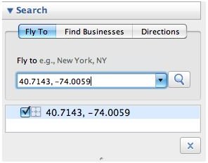
Inserting a satellite location using Google Earth is simple and straightforward. Have your coordinates handy and ensure that they are properly formatted and contain both latitudinal and longitudinal numbers. Type them into the “Fly to” area exactly as they were displayed on the GPS unit or as they were recorded. After entering the coordinates, either press the Enter key or click the magnifying glass button.
Google Earth should fly to the location you entered and the location should be marked by crosshairs. If there is a problem with your search, Google Earth will notify you. Also, if Google Earth presents a list of addresses instead of navigating to the coordinates, then the coordinates are not valid or are not properly formatted.
At any point while using Google Earth, you can view the coordinates of the point under your mouse pointer. These coordinates are listed at the bottom of the map window and are displayed in degrees-minutes-seconds (DMS) format by default. You can change this option to decimal degrees (DD) in Google Earth’s preferences, if you wish.


