Headlands are prominent features on many coastlines throughout the world that are characterized by high cliffs and sea water surrounding them on three sides. Let’s take a close look at the geological factors and the patient processes of erosion that form these visually striking land formations.
Time and Tide Never Waits
The formation of a headland is a testament to the awesome power of time, tide, wind, and waves as they combine to form the ever changing landscape of our coastlines. A headland is defined as a resistant outcropping of rock jutting out into the sea and surrounded by water on three sides. Headlands are formed as the result of coastal erosion and the tremendous battering power of the sea and its waves coupled with ice, rain, and wind.
First, it’s important to understand the different types of rock that comprise a headland because not all rocks will erode at the same rate. Stronger rocks will hold out for much greater lengths of time in the face of waves, ice, wind, and rain than their weaker counterparts will. Geologically speaking, we’re talking about what are simply deemed as rocks that are more resistant and less resistant rocks which contrary to most scientific terminology, are terms that are quite easy to understand.
Differential Erosion Shapes the Land
Rock that is more resistant is otherwise known as hard rock, consisting of chalk, granite, and/or limestone, which does not break down or erode easily against the tremendous power of ocean waves . Less resistant rock will wear away more quickly, as is the case for the examples of it including clay, shale, and sandstone. These two types of rock are found in alternating bands along many coastlines.
The layers are predominantly alongside each other (with either less or more resistant rock dominating the density) which accounts for these peninsulas and inlets due to the effect of erosion. In other words, bands of hard and soft rock outcrop to the coastline at right angles. In geological terms, the quicker or slower rates at which these bands of hard mineral aggregates breakdown is known technically as differential erosion.
What Is Left Behind
Two major forms of coastal erosion contribute to the formation of a headland. The first and most obvious is known as Hydraulic Action, which is the force of water against the cliff face and the types of rock it consists of.
The second is known as Attrition, and just like it sounds, it means that as rocks crumble and fall, they hit other parts of the cliff breaking off pieces there too. The acids found in sea water can also contribute to corrosion of some types of rocks as well. In addition, all that sand and mineral particles in the water almost work like sand paper when waves pound into the rocks.
The mighty waves of the ocean will eat away at the less resistant rock and over time, and that is how bays are formed. Meanwhile, types of rock that are more resistant literally hold their ground and those stalwart headland formations are the result.
Their ability to stand firmly against the forces of erosion and an endless barrage of waves then enables them to become sheltering, protective sentinels to the bays and inlets found at their sides. Depending upon the factors regarding rock types, especially how resistant the hard rock is and the strength of prevailing winds effecting waves, a headland can be rather thin, as in only a few meters wide where it meets the sea. Alternatively, one can be many kilometers wide and anywhere in between those two extremes.
Headlands Are Then More Exposed
Even though in terms of geological time, headlands are resistant to tremendous forces, pounding waves will eventually find their weaknesses and proverbial chinks in their armor.
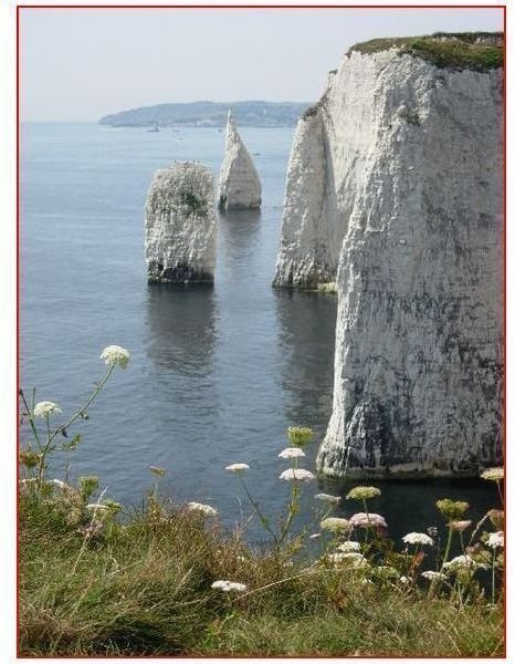
The Dorset coast of England is a stunning example of the beautiful cliff face of a headland. The Foreland, which is pictured here, is a stunning example of a headland consisting of horizontal chalk strata giving it that white gleam.
As you can see, headlands don’t last forever. Over time, after a headland has formed, it is more vulnerable to erosion since it’s exposed on three sides now, much like a boxer that was fighting only one opponent but now has two more on his sides with which to. Waves will pound it from all sides and wind and rain will hammer away at every vulnerable nook and cranny. The resulting sea stacks here are known as the famous Old Harry Rocks
From Cracks to Sea Stumps
What happens next is that the forces of wind, wave, and weather break down headlands to create some of the most picturesque geological formations known as caves, arches, stacks, and sea stumps. Although the in-depth analysis “The Formation of Sea Stacks” will give you a more detailed account, a brief description here will help you understand how a headland can deteriorate in stages to form a sea stack as well as give you an idea on the ever changing geology of our coastlines.
All that continuous erosion causes cracks, which later become caves and then arches. In this long and drawn out process, the arches finally give way and you are left with sea stacks out in front of a headland, surrounded by water.
Erosion will eventually turn these sea stacks into stumps until they eventually disappear into the sea. Now that you know how a headland is formed, you can better appreciate the power of nature in the geological process of creating land forms. Impress your friends and family with this information the next time you gaze upon these stunning coastal features.
References
Coastal Land Forms – Features and Formation: GeobytesGSCE.blogspot.com
Emiliani, Cesare. Planet Earth: Cosmology, Geology, and the Evolution of Life and Environment. New York: Cambridge Press, 1992.
Image Credits
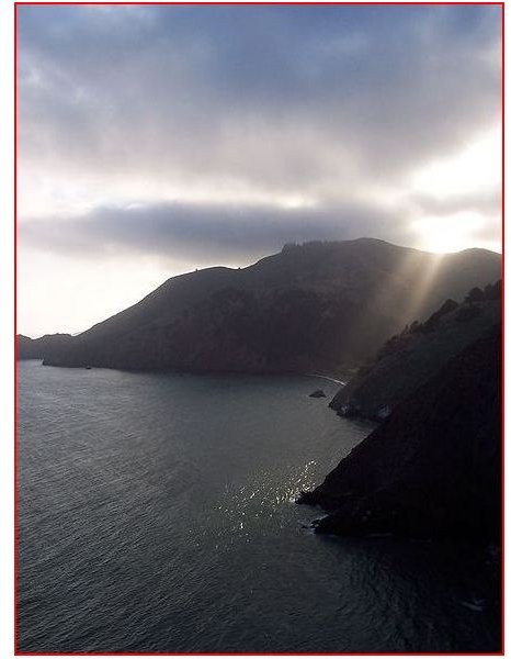
Image: The Marin Headlands as seen from the Redwalk near the Northern Tower of the Golden Gate Bridge by Christopher Beland under Public Domain
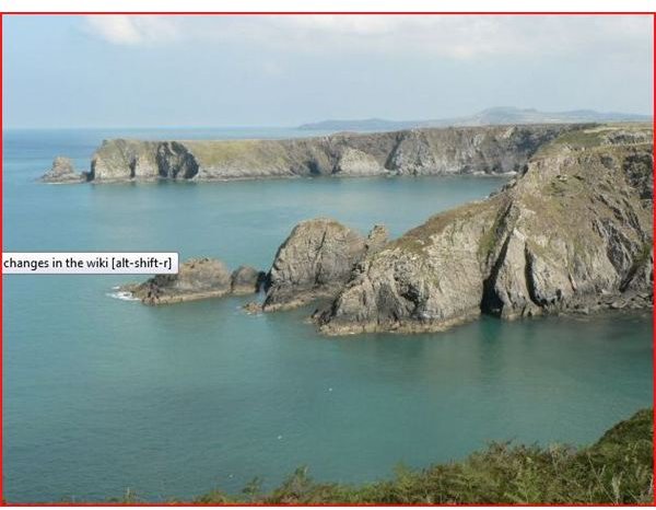
Image: Two headlands . The first headland separates Pwll Olfa from Pwll Llong. The further headland is Pen Castell-coch. These are the only two points of land in the grid square. by Attribution: Rob Burke under CC BY SA 2.0
Image: The Pinnacles . Chalk stacks on the Dorset coast south of The Foreland and Old Harry Rocks by Attribution: Val Vannet under CC BY SA 2.0
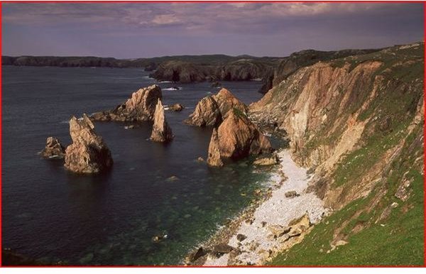
Image: Sea Stacks Mangersta by Attribution: Tom Richardson under CC BY SA 2.0