The landforms of the United States include a spectacular array of topography from some of the world’s biggest canyons to glacially scoured mountains. Here we examine a description of a few of the most basic kinds of geomorphic structures.
Landforms and Physiographic Provinces
Landforms are specific expressions of topography, like canyons or river deltas. Landforms of the United States fall within larger physiographic provinces , which are regions of common or related geomorphology. For example, the glacial hills and plains of southern Wisconsin belong to the Central Lowlands, a huge interior basin bordering the Great Plains, the Appalachians, the Ozark-Ouachita complex, the Atlantic-Gulf Coastal Plain and the Canadian Shield. Major mountain chains–like the Appalachians, the Rockies and the Cascades–often constitute their own physiographic provinces.
Mountain Landforms
Mountains in the United States glaciated in the recent past show striking landform evidence of active ice erosion. Alpine glaciers erode peaks into sharp horns, strongly evident in many of the ranges of the Rocky Mountains , such as the Tetons. Cirques are bowl-like amphitheaters that once harbored glaciers; many in the Rockies, Cascades and Sierra Nevada now support high-country lakes called tarns. The Cascade Range showcases a number of kinds of volcanoes fed by a subduction zone along the Pacific Coast, including massive but subtle shield volcanoes and the classic, conical stratovolcanoes like Mount Hood . The ancient, heavily eroded Appalachians of eastern North America include seemingly endless ranks of low, knife-edged ridges and intervening valleys.
Other Glaciated Landforms
Continental glaciers advanced over much of the northern portion of the contiguous United States during the last Ice Age better than 10,000 years ago, and the evidence of their onslaught is still fresh on the landscape. Drumlins, for example, are teardrop-shaped hills sculpted by glaciers, with their narrow, pointed ends indicating the direction of the ice sheet’s spread. Kettles are circular hollows where isolated chunks of glacial ice remained temporarily after the main ice bodies retreated; eskers are low, narrow ridges marking tunnels in the bellies of glaciers. Lakes are numerous in much of the formerly glaciated country of the northern U.S., as well as significant portions of Canada and Alaska.
River Landforms
The most dramatic of alluvial landforms of the United States, as elsewhere, are great canyons and gorges excavated by rivers through layers of rock. The Grand Canyon in northern Arizona’s portion of the Colorado Plateau has been gnawed out by the Colorado River and its tributaries over millions of years; it is over a mile wide in places and showcases immense spreads of geologic time in its colorful sedimentary layers. Hells Canyon , occupied by the Snake River along the borders of Oregon, Idaho and Washington, is even deeper. In gentler, low-gradient terrain, mature rivers begin meandering, forming broad floodplains dotted with swamps, marshes, abandoned channels and oxbow lakes. River deltas form where a stream, approaching its mouth in a larger body of water like an ocean, widens and slows, depositing large amounts of sediment and often fraying into numerous channels. The most famous in the U.S. is the Mississippi Delta, a classic example of a bird’s-foot delta–named for its palmate shape.
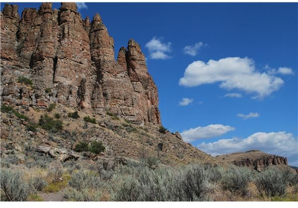
Other Erosional Landforms
Mesas and buttes form when a resistant rock layer overlays less resilient material; the erosion of surrounding, yielding strata leaves these flat-topped highlands standing above flat plains or basins. While most associated with the spectacular slickrock contortions of the Colorado Plateau, they can be encountered in many regions: The castellated mounds of Wisconsin’s Central Forest, for example, are sedimentary buttes that once stood as islands in a large glacial lake. Other prominent erosional landforms include natural arches, bridges, badlands and pillars.
Credits
(1) Henry, J.A. and J. Mossa. Natural Landscapes of the United States. 1995.
(2) Daniel, G. and J. Sullivan. A Sierra Club Naturalist’s Guide to the North Woods. 1981.