Google Route Planner is a web-based application that uses current maps of countries to help you plan a journey. It’s not hard to learn to use.
When you plan a journey to United States and other countries around the world, Google Route Planner lets you calculate travel time, calculate travel distance (in miles and kilometers), and get turn by turn driving directions.
It also allows users to put in several destinations to plan a journey. You can choose traveling by foot, car, public transit or bicycle (in beta – If you find unmapped bike routes, the streets that aren’t suited for bicycling, etc, just report to Google Maps team).
Google Route Planner Examples
Example 1:
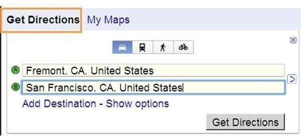
How to drive from Fremont, CA to San Francisco, CA?
1. Go to Google Maps.
2. Click Get Directions link (see red rectangle in the screenshot)
3. In the first destination box: type Fremont**, CA, United States**
4. In the second destination box: type San Francisco**, CA, United States**
5. Click Get Directions button
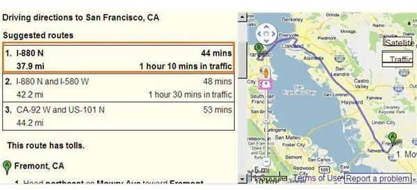
6. Google Maps give you three suggested routes. To see the map, click each number of the suggestion route results:
- Click 1. I-880 N - 44 mins, 37.9 mi - 1 hours 10 mins in traffic (see red rectangle in the screenshot) and see the map. To zoom in the map click + (see pink rectangle in the screenshot)
- Click 2. I-880 N and I-580 W 48 mins, 42.2 minor - 1 hours 30 msins in traffic and so on
7. This route has tolls. To see the maps, click each number of the suggestion route results as above.
- Click No. 1. Fremont, CA. 1. Head northeast on Mowry Ave toward Fremont Blvd until No. 7. Turn right at Market St - 0.3 mi
Example 2:
How to drive from Baden, Mayrhofen to Salzburg - Austria (avoid toll and highways-routes)?
2. Click Get Directions link
3. In the first destination box : type Baden**, Austria**
4. In the second destination box: type Mayrhofen - Austria
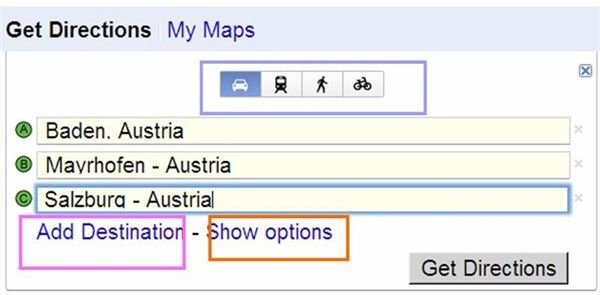
5. Add the third destination box: click Add destination link (see pink rectangle in the screenshot) then type Salzburg - Austria
6. To avoid tolls, click Show options link (see red rectangle in the screenshot) then check avoid highways and avoid tolls options. To see the results in kilometers, click km link (miles is default).
7. Click Get Directions button
8. If you want to choose other transportation methods, such as walking, bicycling, public transit, or car (default), just click one of them (see blue rectangle in the screenshot).
9. To see the map, click each number of the suggestion route results as above example.
Setting Current Location
You can set your current location, if necessary:
1. Click “Set default location link” then type your current location such as “Fremont, CA.”, click “Save” button.
2. Your current location will automatically show in the first destination box after you press F5 keyboard button or click Refresh button on your browser then click “Get Directions” link.
Sending the Suggested Route Results:
You can send the suggested route results to others:
a. Click Send link, click Email link.
b. Type From (your email) and To: (recipient’s email) and click Send button. If you would like Google journey planner send information to your navigation system, click GPS or Car link then click Send button.
References
- Google Maps - http://maps.google.com/
- Screenshots taken by author
- Author’s own experience


