
Wondering what the Google Street View camera vehicles, which capture 360 degree images from the ground, look like? We have that answer here along with information on how the technology progressed and the vehicles changed over time.
Making the Street View Your View
So what does the Google map street view camera vehicle look like? How is it that we can zoom in on a street and pan around 360 degrees to see exactly what you’d see from the street? Since Google maps are known for their satellite images, some folks are apt to wonder how satellites in outer space might generate such views from extreme angles of the earth’s surface. One reason for erroneously believing that is that the alternative (people on the ground taking all those pictures) seems somewhat inconceivable.
Here we’ll clear up that somewhat popular misconception (you’re certainly not alone if you’ve wondered) of how Google maps gets street level photos that you can view for an ever-increasing number of the world’s streets. Maybe then if you see something akin to a Google Bat-Mobile in your neighborhood, you will know what is going on. Speaking of your area, if you want to Get Local with Google Map Features , we have you covered too.
Street View came into being in 2007 with Google operatives capturing images using special equipment and cameras for 360° horizontal panoramic views and a 290° vertical one. Using their unique technology, they weave the collected images together in order for you to see every angle from a given position. It wasn’t just a matter of Google employees walking the streets snapping pictures.
Image Credit:
Wikimedia Commons https://commons.wikimedia.org/wiki/File:Google_Streetview_Art_Car.jpg
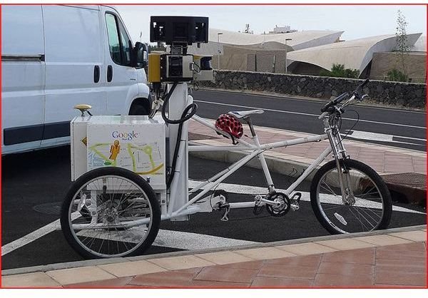
From Vans to Cars to the Trike
At first, they used a special van, a double-decker looking thing, which roamed the streets in selected cities. In order to increase coverage, street view cars replaced the van. About a dozen countries around the world in Europe, North America and in the Asia-Pacific region have street level views available. The Street View car fleet then combed the world so users could remotely view countless public streets.
For even more mobility to photograph national parks, campuses, and trails, a curious looking anomaly (that resembles a cross between a giraffe, an ice cream cart and a bike), known as the “Trike” is used. These new vehicles can cover places that would otherwise be inaccessible. Nine directional cameras, along with a GPS unit and laser range finders, take care of business. Many of these are in the world at any given time. If you’re curious about this aspect of the process, Tips for Taking Better Panorama Photographs might be a good read for you.
It takes months to collect all these views and of course, longer for an entire country. Foul weather is a factor in delaying the photo collection process. All images are then taken to the Google Offices for processing. Pegman is the yellow icon-man that appears on Google Street View as a virtual guide. So now you know what the Google map Street View camera vehicle looks like. The resulting views you see on your screen are really an amazing feature when you step back and think about it.
Image Credits
Wikimedia Commons https://commons.wikimedia.org/wiki/File:20100422gsvt1328x884R.jpg


