Garmin is a forerunner in GPS systems, from handheld to aviation. The company has the Oregon 550 and Oregon 550T models, and both are in our review inside.
Introduction
Garmin’s Oregon series are for outdoor enthusiasts. The Oregon 550 and 550T are rugged GPS handhelds for users who are interested in topography, trekking, and geocaching . The products are really for serious use; to get dirty, wet and muddy.
Specifications (4 out of 5)
The Oregon 550 and 550T each measure 5.8 x 11.4 x 3.5 cm and weigh 197 grams. The TFT touchscreen is 3”. The batteries are AA sized and the device uses 2 of them. The battery life is a whopping 16 hours. An AA battery charger comes with the box.
As is the case for other Garmin products, the GPS receiver chipset is unknown.
Design (4 out of 5)
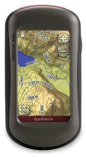
The units reflect the standard Garmin quality and look like touchscreen smartphones. The unit is operated through the soft menu on the touchscreen, and the microSD card is located under the back cover of the device. The ON/OFF button is located at the top. The USB cable is included in the box.
Garmin supplies a belt clip with the device to secure it on yourself. The clip is metal and looks durable.
Features (3 out of 5)
- Topographic maps
- Camera
- Compass
- Barometric Altimeter
The Oregon 550 and 550T have every feature the same except one: the Oregon 500T is preloaded with topographic maps.
Both of the products have 3.2 Megapixel cameras with autofocus and 4x digital zoom. At first it seems to save you from carrying another camera in your backpack but the image quality is just average. However, we don’t deny that it’s nice to have a camera on the unit. The devices feature geotagging , which records the coordinates (latitude and longitude) in which the photo is shot to the EXIF information, which enables you to see exactly where each photo is taken. You can also display and share your photos in Flickr or Panoramio.
Oregon 550 and 550T both have an electronic compass, which can tell you where you are heading and has tilt compensation, meaning that you do not need to hold the device level (parallel to the ground) to get the best reading.
One of the remarkable features of the devices is the barometric altimeter. The altimeter determines your precise elevation by taking the atmospheric pressure. The units also plots barometric conditions so that you can keep an eye on weather conditions. I think Garmin has just missed a point here: a temperature sensor and logging capability would make for an excellent weather station.
The models in the Oregon 550 series have 850 Megabytes of on board storage space but can be expandable with microSD cards. However, the microSD cards are just for adding additional maps via MapSource and BlueChart g2. There are no multimedia capabilities present such as listening to mp3. Therefore, we can say that the device tends to be for a more serious (or professional) type. Still, I must admit that I’d want to have these features.
You can send your waypoints, geocaches and tracks to other Oregon and Colorado users wirelessly from the 550 series. The products also support geocaching, a favorite hobby of many people.
Price to Performance (2 out of 5)
The Garmin Oregon 550 lists at USD 500 and the Oregon 550T at USD 600 from Garmin’s website. The prices are high and given that the Oregon 550 does not include topographic maps, there is no feature to justify this price, even with a 3.2 Megapixel camera. The Oregon 550T has topographic maps but the price is again too high.
The products do not yet appear at Amazon.com.
Overall Evaluation (2 out of 5)
Looking at the devices in general, if you are interested in topography, you would probably want to go with Oregon 550T. The Oregon 550 makes no sense to buy because it is more of a crippled product than a “real” product. If you want to go with an outdoor GPS, I definitely recommend you to go with the Garmin Rino 530 HCx, which is USD 376.78 at Amazon.com.


