Geological mapping was a difficult procedure involving multiple complex technologies until researchers discovered the potential of GIS. With the application of GIS in geological mapping, it became very easy for surveyors to create 3D maps for any area with precise and desired scaling.
Geological Maps – An Introduction
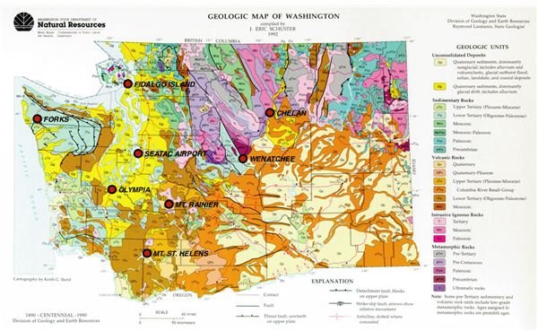
A geological map (also called a geologic map) is a special map that displays the geological features of an area. Different colors (legends) are used to show the rock formations, canyons, valleys, plains, and other features of the area being mapped. Lines are used in these maps to convey characteristics of the land. These lines help in estimating the height of these terrain-structures. The height is displayed in comparison to sea level. The lines in geological maps are followed by a number, which indicates the incline of these structures.
Before the entry of GIS into the field of geological maps, it was very difficult to map any area with maximum precision. Numerous techniques were used to obtain precise data, which involved multiple complex devices and thereby multiple calculations.
The following sections offer a briefing on GIS and how application of GIS in geological mapping results in accurate measurements that help in several fields where geological mapping is required.
Geological Mapping – 2D and 3D Mapping
3-D views offer a much better understanding of anything compared with 2-D images. For example, a picture of a monument is 2-D and cannot give you many details until you see the monument in 3-D. Consider the map of an area with lines that can give you height and width of different formation but fails to deliver information about the depth. You are missing potential information about the area.
If you wish to build a road in the area with the help of the 2-D map, you know the structures and obstructions in the area and can design a road accordingly. However, can you determine how much material will be required? Suppose the 2-D map contains a valley. You know you can build a road through the valley. You can determine the length and width of the road and will thus, get some idea of the material required to build the road. However, what if the valley is too deep?
.
You also need to study the depth of the valley so that you can get an idea of how much material is required to build the road through the valley. The term “D” in the above paragraphs refers to the term “Dimensions” in physics. Physics employs three planes (also called axis that are represented by X, Y, and Z) to show the height, width, and depth of any particular item on the planet.
You may wonder how these planes are related to geological mapping. The following section will help you understand the point.
Application of GIS in Geological Mapping – Fast, Accurate, and Cost-Effective
Geological features are dependent on space and time. The Geographical Information Systems (GIS) are capable of defining all three factors of space (represented by the X, Y, and Z planes) and time. The signals from the satellites allow the GIS to read information in term of longitude, latitude, and elevation (compared to the sea level). This information helps in determining all three planes that guide GIS tools in creating a 3-D image of the area under survey.
The satellite signals also send in information about the time when the satellite released the signals, clock redundancy of the transmitters in the satellites, and coefficient of error through the speed of signal in the space as well as in the different layers of atmosphere. Based on these four factors, surveyors can create accurate geological maps of the area under survey.
Though the old methods of geological methods (based on multivariate statistics ) are still in use in some countries, the GIS is the most preferred as it is cost-effective and offers more accurate data, thereby easing the scaling process when studying geological maps.
GIS helps in scanning, referencing, and reproducing older maps at any desired scale. Using GIS, several archeological geological maps (having different scales) have been combined into a single map (with single scaling) with even more accuracy, thus saving the time of scientists, engineers, and researchers who need to study the area.
Using the accurate scaling obtained from GIS, different projects can be planned without the need of additional equipments for surveying the area. The different projects that can be planned and implemented using applications of GIS in geological mapping can be anything from creating a dam or reservoir to roads, highways and railroads to an entire town. The benefits of application of GIS in geological mapping are visible when different projects can be entirely planned without even leaving the conference room!
This post is part of the series: Application of GIS in Geological Mapping - GPS and Surveying
This article series offers information on the applications of GIS in Geological mapping. It also covers GPS in surveying. Surveying using GPS is now easier than manual methods. This series aims to shed light on GPS surveys while also discussing some GPS survey equipment.


