Do you sometimes look at your tiny little GPS device and wondered how and why scientists thought of such an invention? Here is a brief history of GPS technology.
A Brief History of Navigation Systems
Navigation can be defined as going from one place to another while logging your position periodically and as necessary. In older times, our ancestors looked at the sky and made various calculations to determine their location on earth. For hundreds of years, seamen used celestial objects – this continued until the 1940s. Then, various navigation systems emerged: DECCA, LORAN, and OMEGA. However, these all required special charts and the positions calculated were not “pinpoint” positions in many cases.
Fruits of the Cold War
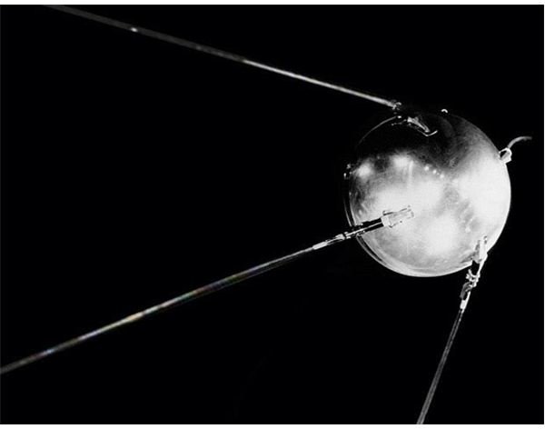
When the former Soviet Union launched their satellite “Sputnik” and placed it in orbit, a team of scientists in the United States began monitoring the radio transmissions from the satellite. The team discovered that when Sputnik came close to their location, the frequency of the signals increased only to decrease again when Sputnik started moving away. This is due to the Doppler effect and it can easily be reverse engineered: if I know exactly where I am on Earth and I can measure the Doppler distortion, I will know exactly where the satellite is.
So what happens if I know where certain satellites are, but don’t know where I am?
Global Positioning System (GPS)
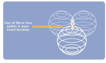
The Global Positioning System stemmed from this idea and was later on refined. There would be satellites orbiting the earth, with their positions known in advance, which were transmitting their orbits and the time of each message. That way, the GPS receiver would receive the signals and compute the distance from each satellite and thus determine its own position. To do this, however, at least three satellites are required. The reason for that is simple: the signals emitted by the satellite are spherical in shape (imagine emitting signals from a point to all directions). If you add another satellite, whose signals are also spherical, the intersection will also be spherical. In positioning we need to know “exactly where we are” rather than our “whereabouts.” Therefore, there should be a third satellite that makes the intersection a “point” rather than a “circle” that we are somewhere inside.
Global Positioning System was first installed by the United States Department of Defense and was used for military purposes only. It was 1983, when Korean Air Lines Flight 007 unknowingly entered the prohibited air space of the former Soviet Union and was shot down by USSR forces. Immediately afterwards, President Ronald Reagan of the United States issued a directive to make the Global Positioning System public and allowed its use by civilians.
Image courtesy of TomTom .
What is the Precision of Global Positioning System?
From 1983 to 2000, only military devices could receive the perfect signal to find their location. Civilian devices received a poorer signal and thus could find their locations with only 100 meters precision. In 2000, the signal degradation was lifted and now all GPS receivers have a precision of 20 meters.


