Landsat 7 is up in space right now observing planet Earth with stunning accuracy and an eye for qualitative and quantitative detail. The images and data the Landsat program has provided to scientists and researchers since its inception have been invaluable, illuminating, and spectacular.
A Marriage Made for the Heavens
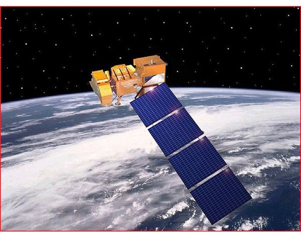
Landset 7 is the last satellite sent up to steady its digital gaze upon our planet to study it just like its predecessors did for as long as they were able to. Landsat is the name given to the joint program between NASA and the U.S. Geological Survey (USGS) that is dedicated to collecting information about the natural resources and climate on the planet where most of you are from, Earth. Since NASA is as crazy for space as they are about creating acronyms, this one in particular stands for Land Remote-Sensing Satellite (systems). The purpose of launching this series of satellites was to enable repetitive coverage of the Earth’s surfaces using the constantly evolving remote sensing technologies discussed below. Similar in some ways to GPS satellites , Landsats were intended to orbit in a pattern and be staggered over time to expand coverage. The timeline for the seven Landsat satellite missions in terms of when they were launched and how long each satellite operated is as follows:
**
Landsat 1 (1972 - 1978)
Landsat 2 (1975 - 1982)
Landsat 3 (1978 - 1983)
Landsat 4 (1982 - 1993 Note: Landsat 4 stopped delivering scientific data in 1993 but wasn’t decommissioned until 2001.)
Landsat 5 (1984 - still in service as an amazingly durable workhorse in space)
Landsat 6 (failed to reach orbit, a privatized effort that failed)
Landsat 7 (1999 - still in service but not functioning at maximum capacity)
Image courtesy of Wikimedia Commons
Up There to See What’s Going on Down Here
The USGS studies the great breadth of sciences related to our planet including atmospheric conditions, oceanography, the climate, geology (the history and present conditions on the ground), magnetic fields, environmental science and issues relating to human impact, and of course, cartography. And that is just a sample of what they do. So from earthquakes to glaciers to plate tectonics, it’s their job to know what happened when and how it happened. With an understanding of that knowledge they might be able to accurately predict what’s in store for the most stunning planet in the Universe. Landsat 7 data enables scientists to study the way natural processes affect the Earth over time (coastal erosion is one small example). But, one of their most important jobs is to monitor the activity of the one species on Earth most prone to intentionally ruining a good thing, we humans. We can only hope that Landsat satellites will never record the devastating effects of a nuclear war.
Since the U.S. Geological Survey has always been a leading authority on so many of the sciences related to the Earth and its climates, they were the perfect partner to bring on board to do what they do best, only from space now. Not literally of course, Landsat has always done its Earth-observing using unmanned satellites since the inception of the program in 1972. The USGS and NASA make heads and tails out of all that imagery and digital information to determine what is Landsat data that can that can help researchers study agriculture, forestry, climate change , water quality, flooding impacts, and just about anything and everything related to the natural resources of the Earth. Researchers in a vast number of fields, hailing from a multitude of organizations study the data compiled from Landsat satellites for all sorts of practical applications. NASA and the USGS don’t hoard the information in that way.
Landsat 7 is Most Touted for its ETM+ Platform
The National Oceanic and Atmospheric Administration (NOAA) is also firmly entrenched in this program as well, and the imaging technology has become so advanced that Landsat satellites help map the topography of the ocean floor . Landsat 7 introduced the Enhanced Thematic Mapper (ETM+) platform. Among its many amazing capabilities stemming from monitoring eight spectral bands, far beyond standard satellite imagery, Landsat 7 can do things like decipher and assess the health and heartiness of vegetated surfaces using what is known as Normalized Difference Vegetation Index. With this kind of information, agencies responsible for managing lands at both the state and federal level can be better stewards of their land and more effectively manage habitat. For instance, in New Jersey, Fish and Wildlife officials used Landsat data to figure out which land should be saved from development in order to protect endangered species and best manage their resources. The regrettable loss of the Scan Line Corrector of the ETM+ while in orbit has impacted its imagery to some degree, but Landsat 7 is still believed to be the best Earth-observing instrument ever placed in orbit, which says a lot when you consider all the invaluable information we gleaned from its six forbearers. With that said; anyone with a fighting, never-say-die spirit will be partial to Landsat 5 because it’s still up there working, battered and bruised but not ready to give up.
The Landsat Legacy
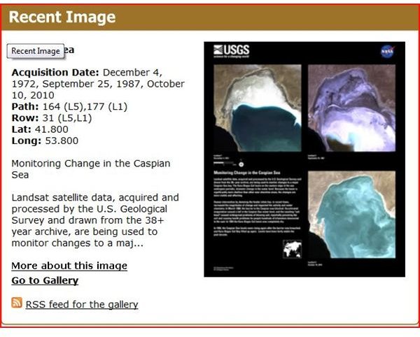
Over the last 30 years, the science of remote sensing inherent in the Landsat program has evolved to the degree that a great deal of information can be gleaned about coastal ecosystem decline and erosion just from simple satellite imagery taken over time. For instance, take a look at the dramatic changes that have occurred in the Caspian Sea that a series of Landsat satellites have recorded, which you can see to the right, and learn a great deal more about at landsat.usgs.gov . A huge factor in the changes to the Caspian Sea was the result of human impact in the form of a dam. Landsat has tracked erosion and shifts in coastlines all over the world. More subtle variances in Landsat data recording will detect pollution and other ecological changes. Landsat imagery was pivotal in helping officials deal with the recent catastrophic oil spill in the Gulf of Mexico.
When I first heard of a recent study in which Landsat data was used to hunt for tiny deer ticks, which cause Lyme disease in Alabama forests, I was flabbergasted to think that satellites from outer space could spot ticks when I never even saw the deer tick that gave me Lyme disease years ago. Upon further study, I realized our scientists hadn’t quite gotten that far yet, but I wouldn’t be surprised at all if that kind of reverse telescoping ability will be achieved in our life time. Instead, they pinpointed the type of habitat where deer ticks would flourish. If you’re interested, take a look at the websites below for more fascinating information and images regarding Landsat Missions and imagery. The USGS website even has a link to see what is being recorded live up there.
Sources
https://landsat.gsfc.nasa.gov/about/landsat5.html