The Google Maps Distance Measurement Tool makes it easy to calculate the distance between two or more points anywhere on the planet we all inhabit. Here, we’ll explain how it works and provide quick and easy-to-follow instructions so you can use it.
How the Google Maps Distance Calculator Works
The Google Maps Distance Measurement Tool enables anyone to measure the distance between two or more locations anywhere on the globe. It’s a handy reference for anyone wanting to know how far one place is from another for any reason whatsoever. Keep in mind that this measuring tool simply calculates the distance using the latitude and longitude coordinates from point to point. Therefore, the calculator takes in no account of elevation which can add considerable distance if you’re measuring between two or more places in mountainous or canyon areas of the world. If you are a crow that can read, you have nothing to worry about; distances will be spot on. But obviously, roads are not perfectly straight, so if you want more exact driving distances, you’ll want to use the “Get Driving Directions” link on Google Maps that measures road miles. That useful tool was pointed out by a helpful reader by the name of Corey.
If you’re just curious about the distance between any “A” and “B” of your choosing, this is a neat feature. The tool just keeps adding the total distance cumulatively, no matter how many different places you click on after choosing the starting point. Incidentally, have you ever wondered if Google Earth and Google Maps are one and the same? While there are many similarities, there are also a few key distinctions in these programs, put out by the same behemoth software company, which you may be unaware of that might also be of some interest to you. Satisfy your curiosity by reading What is the Difference between Google Earth and Google Maps?
Instructions on Using the Google Maps Distance Calculator
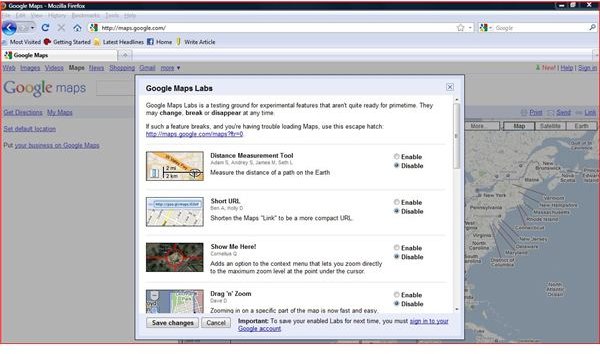
All right, so now you know what it is, let’s get right to what you need to do to work this Google Maps Distance Calculator tool. The good news is that there’s not much more to it than simply enabling the function once you’ve got Google Maps on your screen. Just click “New” on the upper right hand screen (as shown in the first screenshot here) and a dialogue box appears titled “Google Maps Labs.” Right there as your first option, you’ll see the “Distance Measurement Tool.” Simply click enable and then scroll down and hit “Save Changes” on the lower left of the box and the tool is ready to go to work for you.
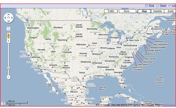
Back on the map, the tool appears as a ruler icon on the lower left hand side of the screen (second screenshot). Click on the ruler and it first gives you the option of measuring in “Metric”, “English (miles)”, or “I’m Feeling Geeky” (measures in unconventional units like football fields or Egyptian cubits,
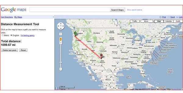
for example). Then just click a place on the map to start from and it automatically calculates the distance from your starting point to however many other places you select. You can delete the last point or reset anytime you want. On the last screenshot shown here, you’ll see that the distance from Portland, Oregon to Albuquerque, New Mexico is 1099.67 miles. There you have it; this is a really straightforward tool to use, so play with it to your heart’s desire.
But while we’re talking about Google’s mapping capabilities, perhaps you’ve noticed, while zooming in on certain areas of the globe using their satellite imagery feature, that there are blacked out and fuzzy images in many places. What is that all about? Find out by reading Excluded Images on Google Earth: the Blurry Stuff . It’s a two-part series that explains where you’ll find these patches and why you’re not allowed to see
these them. Conspiracy theory fans will greatly enjoy the interesting bits of mysterious trivia found in those articles.


