Google Earth is a fun program for both education reasons and just messing around. One new interesting feature is the ability to use live flight tracking in Google Earth. I’ll give you some quick info about this fun new feature.
Ideas for Live Flight Tracking
Google Earth has a nice new feature to allow you to track a flight plan in real time. Before I cover the basics of actually tracking the flight, I thought I’d go over a few good ideas for making use of this tool.
One of the best that comes to my mind is that it will create a fun way for relatives and kids to track a flight. If you’re coming in for a visit, then I can bet that little brothers and sisters/nephews and nieces will be bouncing off the walls. Watching your flight move across the country should be an interesting little distraction for them. Obviously it can be a neat thing for relatives and friends to do too, if they like playing around with technology. If you like playing around with technology, then you can also learn some more about the cool features of Google Earth along with some ideas for the Google Earth Flight Simulator .
Practical applications are a little limited, but it’s a fun way for you to see whether your flight is on time before you go to the airport. It’s similar to those “Where Has George Been?” websites that track a dollar as it moves around the country. It has little innovation to offer for practical use, but it’s interesting.
Although, if you ever find yourself in some kind of strange betting competition on which plane will land first, then you can cheat (I always prepare for Seinfeldian situations).
How to Use Live Flight Tracking in Google Earth
This is actually a really simple procedure. For the first step, you need to download Google Earth. The free package is all you need. You can download it here .
Once you’ve installed it and got it up and running, you’re ready to track some flights. Find the flight number (or get good at random guessing) and go to Flightwise.com. They keep a number of flight plans on record and they’re a good source. Punch in your flight number and the relevant airline and it will pull up the current schedule and status.
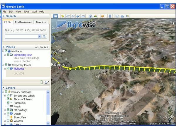
The important thing is the little icon below it with a plus sign and a note about Google Earth. You can click this and it will bring up a downloadable file. It should be set to “open with Google Earth.” The custom file will then quickly download (they’re usually very small files) and it will pull up your copy of Google Earth. The flight should be laid out from start to finish with the plane easily visible. It will even show the relative altitude that has been planned. You can angle the camera down for a fairly cool cross-section view (featured in the picture).
Wrapup
Well, that’s about it. If you want something fun to do with Google Earth, then live flight tracking should fit the bill. It’s a neat little use of a very cool program. It’s also easy enough for just about anyone to do. Just follow these simple instructions and you’ll be fine. Have fun!


