The excluded images on Google Earth are quite obviously blurred out when you try and zoom in on them. Here, we’ll delve into where you’ll find many of them, why they are purposefully made blurry, and why this fuzzy view of our world is so interesting to us.
Human Nature Revealed and Topography Concealed
Why are sites blurry and unavailable? Why are the excluded images that Google Earth conceals from us so interesting? It’s akin to
one of the oldest stories on earth. Since the tale of the Garden of Eden, it has been abundantly clear that a tremendously strong force in the nature of humans is to gain access and seize what they are told they are forbidden to have. The apples might never have left that tree of knowledge, had the couple in the story, Adam and Eve, not been sternly warned not to eat them. A simple nonchalant comment from the Deity such as “Those apples over there, they’re kind of sour. I wouldn’t eat them, but have at them if you wish; just be advised that it will be a long time until you people invent Tums or Rolaids” would have resulted in a completely different outcome.
Personally, I think it’s no different than putting cheese in front of a rat; you’ll get the same result every time (just setting up the conditions for failure). Similar tales reverberate throughout virtually all of the cultures that span this planet we inhabit and the history of its peoples. At the very least, people want a valid explanation of why they are prohibited from seeing something, which in this case, involves world-wide excluded images Google Earth doesn’t allow users to view. So, let’s attain some clarity to what appears fuzzy and blurry on Google imagery before I have some lightning bolts hurled my way. Also, if you’re at all fuzzy about how this program works, maybe you should read Understanding Google Maps to find out how accurate it is.
What They Don’t Know Makes It Harder to Hurt Us
The main reasons are to prevent terrorist attacks on high value targets. In the U.S., those targets include energy stations (nuclear and otherwise), pipelines, communications stations, and research facilities (MIT and Stony Brook for instance are blurred). Blurring sites is perhaps a more subtle camouflaging technique than the blacking out that we discussed in the first article of this series. Areas around the blurred spots can be seen in great detail but when you get close to the blurred installation by scrolling, you can’t decipher anything. In some cases, the blurring is done by creating a series of honeycombed shapes that remind one of a cloaking device from a science fiction movie. You just can’t zoom in for a closer look. Find out what you can do though by reading Cool Ways to Use Google Earth .
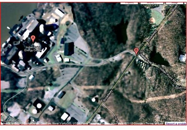
Many nuclear stations, energy-generating sites, and reserves are blurred for the good reason that they are high value targets. For instance, you can view houses and yards with perfect clarity in Westchester County New York until you get to the Indian Point Energy Center, which is blurred out. Not that far away in another part of the same county, in a town called Rye, there is another blurred out area. At that place, they very obviously attempt mind control by strapping citizens on open cars, and then running them on rails at great speeds, upside down in a series of loops.
Many other diabolical torture machines are also on this property. However, you can’t see them on Google Earth. You have to buy a ticket and go to the amusement park known as Playland to see them firsthand. Then, everything will look blurry after the roller coaster too. Things are just never what they seem. In the same county again, where my beloved mother graduated with highest honors from Manhattanville College, a few dormitories are obscured from view (next to Pepsi’s Corporate Headquarters). The reason for all of these blurry images is that Westchester County, which is adjacent to New York City, was understandably proactive about asking Google to blur out potential places terrorists might attack, and in some cases, the blurriness overlaps adjacent properties. It’s not because Playland doesn’t want Six Flags amusement parks snooping around for ideas.
Prime Examples Around the World
Why these blurry Google Earth images all over the world? Many nations have tacit agreements (mostly behind closed doors) to preclude people from using Google Earth to view what they feel to be viable targets for terrorists. Enemies of their states would have a much easier time planning and executing an attack when they can see their target in great detail. Our most pivotal Air Base in Germany, Ramstein, is blurred out as it should be because that is where the majority of our troops fly in and out of when traveling to and from combat operations in Iraq and Afghanistan. None of the Forward Operating Bases that I was stationed at in Iraq, or any other bases in Iraq that I could see, are blacked out or visibly blurred.
Greenland has military camps that are blurred out. England has its share, and you’ll find other examples throughout Europe, Russia, and China. Interestingly enough, Google doesn’t have a uniform manner of blurring images and you will find discrepancies in the way it’s done, which perhaps is agreed upon in exclusive agreement between Google and each nation.
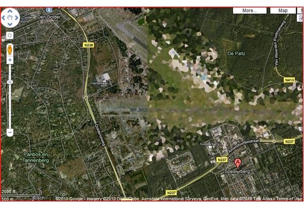
The Netherlands has a very large number of blurred out terrain which include various military bases, air strips, and government buildings. There is some irony in the Netherlands having so many blurred out patches, considering the region is well known for the legality of drugs, which produce a certain amount of foggy, cloudy images in the brains of humans. Take a look there for the best examples.By the way, if you don’t know how broad-minded and far reaching this website is, read this cool story called Civil Engineering Wonder – Netherlands North Sea Protection Work to get an idea.
Keep in mind that just because an area isn’t blacked out or blurred, doesn’t mean something there can’t still be concealed just like someone might doctor a photograph with Photoshop. Superimposed images are sometimes placed over what is really on the ground. That is what was done for the White House and the Capitol. Older images are what you see on Google Earth to conceal the updated defensive weaponry that is in place since 9/11.
There you have it. Most likely, any blurring you see is due to security reasons, although in a few isolated instances, Google blurred properties when requested for right-to-privacy reasons (or they were sued). And now with Google Street View, there are many more cases around the world where people object to this Big Brother-like presence. Perhaps we shall cover that in a future article.
This post is part of the series: The Things Google Earth Won’t Let You See
Google Earth has satellite imagery that spans the entire earth yet there are many places around the world that are either entirely blacked out or are blurred so you can’t see any detail whatsoever. This series delves into the where and why of this mapping mystery.


