What is the geology of the Mt. Fuji volcano? Japan’s most famous landmark and highest mountain in the country is a stratovolcano.
Mt. Fuji: Geology of a Volcano
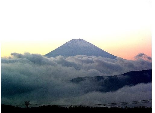
Japan’s most famous volcano, Mt. Fuji was last active in 1707, but is still classified as an active, but dormant volcano. The country’s highest mountain at 12,390 feet, it is also Japan’s most recognized feature. Located on the island of Honshu, Japan’s largest island, it sits due west of Tokyo between the prefectures Shizuoka and Yamanashi.
Geology of Mt. Fuji
Mt. Fuji is a composite volcano, also known as a stratovolcano. This means the mountain was created by a series of eruptions through many years. Mt. Fuji is characterized by its distinct steep slopes and cone shapes, making it appear that the volcano has bumps along the side. These cones form due to eruptions of viscous lava, tephra, a form of volcanic ash made from fragments of rocks, and with pyroclastic flows. Pyroclastic flows are superheated rocks, ash and dirt erupting from the volcano at high speeds that can oblierate anything and everything in their path. They have the appearance of gigantic clouds of dust, speeding from the mountain during an explosive eruption. Volcano Vocabulary Terms describes volcanic vocabulary terms.
The pressure it takes for a stratovolcano to erupt can take thousands of years to build up before finally expelling through the volcano’s venting system. Composite volcanoes have more than one kind of magma within including basalt, dacite and rhyolite. Basalt magma is the only kind of magma that can not create an explosive eruption of the volcano. Stratovolcanoes tend to have many vents including cinder cones and domes found low on all sides of the volcano. Classifying the Three Main Types of Volcanoes explains volcanic types in detail.
Tectonic Plates
Mt. Fuji sits on a subduction zone of tectonic plates where the Philippine plate is sinking beneath Japan. A tear in the Philippine plate was discovered by scientists at the University of Kyoto, allowing high volumes of mantle to keep Mt. Fuji’s magma chamber filled. The belief is this tear was created approximately two million years ago by a collision of continental plates nearby. Scientists agree that this tear is the primary fuel source of Mt. Fuji.
Phases of Development
According to scientists, there have been four distinct phases in the creation of Mt. Fuji. Sen-komitake was the first stage and is comprised of an andesite core deep within the mountain. The second stage was the basalt layer known as the “Komitake Fuji,” formed several hundred thousand years ago. “Old Fuji” was created 100,000 years ago and finally, roughly 10,000 years ago, “New Fuji” was formed.
After the last eruption in 1707, a new crater was formed along with a second peak named Hoei-Zan after the era. The second peak was created halfway down the side of the mountain.
Monitoring the Mountain
Scientists continually monitor Mt. Fuji for any sign of an eruption. Since it is located where the Eurasian Plate, Okhotsk Plate and the Philippine Plate meet, the area is prone to earthquakes. When seismic activity occurs, scientists measure magnitude and the number of earthquakes to determine if the volcano will erupt. Any changes in earthquake frequency and magnitude, or changes in size of Mt. Fuji could indicate a potential for eruption. Seismologists and Volcanologists use this information to warn residents of possible danger as well as to learn more about the mountain.
Mt. Fuji
Photo Credit
Mt Fuji by Jenniferphoon on Flickr CC