From the Gobi desert to the highest point of Mount Everest in the Himalaya’s, China is a beautiful country. The various landform types of China contribute to the natural beauty, with three in particular making up some of the most breathtaking views.
The Make Up of China
Landforms of China run the gamut from desert to the tip of Mount Everest. Mountains, desert and lowlands all are a part of China, making it the breathtaking sight it is. Home to the Himalayan Alpine range and the Gobi desert, China is filled with wonders to look at in terms of interesting landforms.
With two main seasons of winter and summer, climates in China range from a moderate temperature in some parts of the region to some extreme temperatures due to the desert area as well.
While the country has various types of landforms, the 3 major landforms in China are the foundation of the most well-known areas.
The Himalayas
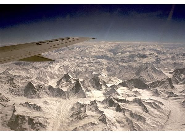
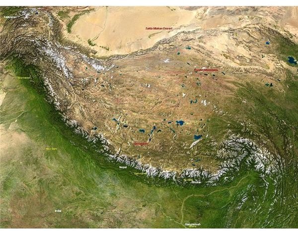
The Himalayas (Sanskrit for “abode of snow”) is a range of three varying heights of mountainous regions that run through the Asian region. The range begins with a sharp rise from the Gangetic Plain. The Tibetan Plateau lies north of the mountains, known as the Earth’s highest mountain range. Famous peaks shoot from this mountain range, such as Mount Everest, K2 or Mount Godwin Austen, Kanchenjunga, and Nanga Parbat.
Thirty to fifty million years ago, the Himalayan range developed from a process known as plate tectonics, which pushed the Indian plate against the Eurasian continental plate. This process created the range of mountains and is still at work today. The moving plates rearranged the deposits that lay in the shallow sea known as Tethys. Earthquakes and tremors occur often in the area even today, as the range continues to move, shift and change.
The Himalayan mountain range pushes skyward from Pakistan through northern India and follows suit in Nepal to Bhutan and onward to the Burmese border. As the plates form the range, they lie in separate zones. These zones are known as the Great Himalayas, the Middle Himalayas and the Sub-Himalayas. The sub-Himalayas include the Siwalik range and the foothills. Two areas of land that lie at the base of the mountain range are Tarai and Duars, which are both included in the sub-Himalayas as well.
Great Himalayas:
Within the Great Himalayan region are several of the most inaccessible areas of the world. Clustered settlements are located in the higher valleys; however, winter weather that lasts for many months, leaves a shorter crop season deters most farmers. Farmers surviving this section of the mountain range are limited to one crop per year. Potatoes or barley are the crops that survive the best in this region, due to cold weather and the shorter warm temperature seasons.
During the summer, the oldest trails are open that cross through the mountain passes that allow some trade between Nepal, Pakistan and China. Although the construction of highways links the three regions, they are limited due to the mountainous layout.
Middle Himalayas:
Running along the south of the Great Himalayans, the middle Himalayas has an average width of 50 miles that contains mostly higher ranges within and outside of the Great Himalayas. Mountain ranges that lie within the middle Himalayas are the Nag Tibba, Dhaola Dhar, the Pir Panjal and the Mahabharat. When the middle Himalayas was formed during the plate tectonic process, an amazingly uniformed height was created.
Between the forested ranges and valleys that lie fertile, the formation of an isolated area from the plains of the Indus and Ganges rivers in Pakistan and northern India became the middle Himalayas. The mountains work as a “wall” of sorts, to separate the valleys from the ranges. The area is moderately populated, with few roads and routes between towns. Travel remains difficult with this lack of dirt or paved roads. Centers that are higher in population are considered the only links to larger cities such as India and Pakistan.
Sub-Himalayas:
Sub-Himalayas outline the lowest and most southern of the zones, bordering the North India and Pakistan plains. Gradually narrowing, with the sub-Himalayas being at about 30 miles in width and running until they are almost gone completely. The main feature of the sub-Himalayas is the flat valleys or duns that are spindle-shaped and filled with alluvium. Forests of this region are gone, destroyed as much of the land has been claimed for agricultural use.
The Yangtze River
Made up of a bottom covered with alluvial material, the valley by the lower Yangtze River is surrounded by higher lands with crystalline rocks jutting upward in pure contrast to the flat, smooth lands. The Dabie Shan lies northwest of the valley and the Huang Shan is to the southeast. The sediments in the basin indicate the make-up of several big lakes throughout the plains area. The Wuchang Hu, Daguan Hu, and Long Hu lakes are among them.
The river is a traveling scene for vessels carrying goods to and from various ports through a network of lakes and rivers. Headwaters in southwestern China receive plenty of precipitation during the rainy season in July and August. Typhoons wreak havoc through floods of the lower Yangtze during the rainy season and into September, leaving the world’s 5th largest on average for a yearly basis of rainwater discharge amount. The river carries one and a half times more water and 2.3 times the sediment during one year as the Mississippi and Missouri Rivers.
The flow of the Yangtze River is associated to that of rivers that are connected between parts with branching systems, as it flows around islands and remains more stable than the braided rivers, even under continual modification. Scroll patterns indicate progressive channel migration that is similar to the flow mannerisms of winding rivers.
Tributaries of the Yangtze flow into inland basins used for cultivating rice crops. Dongting Swamp area is the largest crop area in the region. Swampy areas were once home to the Yangtze waters, which have moved to the north. Rivers that flow into the basin flood the mucky area with water. The basin will also be a flow regulator for flooding of the Yangtze. Changsha is the largest city in the region.
Further upstream lies the Dongting Swamp. Gorges such as the Qutang, Wu and Xiling house a heavy flow of the river as it flows through each. Flow depths are huge through the narrow cross sections of the gorges. Through one point, the depth of the Yangtze creates such as deep point that is makes it the deepest river in the world.
North China Plain
Drainage and deposition from the Yellow River and material flowing in from other smaller rivers drain in to make a high contribution to the formation of the North China Plain. The North China Plain receives sediment from not only the Yellow River but also the Taihang and Yanshan Mountains supply elements of their make up as well, flowing in from the smaller rivers that end up in the North China Plain region.
Throughout the years, the tectonic occurrences in the area have greatly controlled the direction of the flow of the Yellow River. Over 25,000 years of sediment has ended up in the plains area, adding to the already 0.23 centimeters a year deposit.
Over the years, the idea of raising the natural levees to prevent the sudden removal of soil by changing river flow, which has caused problems throughout the history for the communities that reside by the plain, has been finalized by creating a dam. The levees were in a constant threatening mode in the region, flooding and instability of the soil surrounding the mouths of the river and of the plain itself.
The building of a dam, such as the preexisting dam known as the Sanmenxia Dam, the Xiaolangdi Dam has been created to hold the flooding waters generated in the upstream areas of the river. It has also been designed to hold sediment for a term of 20 years, which will supply the residents of the plain area an amount of time to come up with an alternative that will be permanent.
With the location of the Loess Plateau, which runs into the Yellow River basin, it supplies some of the erosion and sediment production in this region. In fact, the Loess Plateau greatly adds to the sediment in the area. Loess is currently providing, through erosion, a regional change in the production of grain, as grain size changes from a coarser production in the north to a finer type in the south.
The North China Plain area is greatly affected by the Loess Plain and the Yellow River as well in terms of farming and grain production from erosion and sediment processes. Inappropriate land use by humans adds to the problem of the flooding and erosion; however, most is due to the geological make up of the land itself.
The removal of vegetation and intensive human residency are part of the problem as rural poverty and changes in ownership of land continually enhance the stripping of land elements that keep flooding and sediment occurrences at bay.
The management of the North China Plain region is essential and a key element to reduce the erosion and nutrient, soil and potential farmland loss in the people of the area. The loss of farmland is linked to the Loess Plateau and this element will have to be considered in the decision of land management and whether or not it will have an impact to avoid the natural processes of the river and land surrounding the North China Plain. The relationship between man and nature is in constant battle in this area, to create a farming region that will be beneficial to all that reside in the North China Plain area.
Sources
Microsoft Encarta Online Encyclopedia 2000; Himalayas
Kempler, Steve, “Yangtze River, China”, Goddard Earth Sciences, Data and Informational Services, NASA
Finlayson, Brian, “Managing Soil Erosion on the Loess Plateau of China to Control Sediment Transport in the Yellow River-AGeomorphic Perspective ”, Centre for Environmental Applied Hydrology, School of Anthropology, Geography and Environmental Studies, The University of Melbourne Victoria, Australia, 3010
Images
“Hymalayas ” by Nasa under Public Domain Licensing
“A photo of Himalayan mountains from air ” by Pipimaru under GNU Free Documentation License .
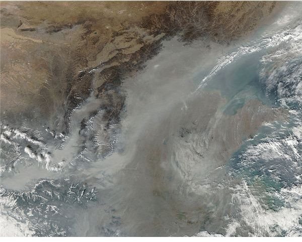
“Haze Over China .” by Jeff Schmaltz under Public Domain License