The entire Great Lakes Basin and the Niagara River are part of the Ice Age. This “fossil water” is less than one percent renewed water on an annual basis; the rest is leftover from the ice sheets that constructed the Great Lakes. How was this amazing area formed?
The Niagara Gorge is Powerful and Useful
An average flow of water that runs through the Niagara River is equal to 212,000 cubic feet of water every second. The water falls a distance of 325 feet from Lake Erie to Lake Ontario. On the average in 1894, the flow of water through the Niagara River was 270,000 cubic feet per second, which is equal to 1,000,000,000 pounds per minute. You can watch the power behind this beautiful spot from both the Niagara Falls webcam and from the American Falls webcam , and the view is spectacular.
With river water flow this powerful, it’s not a wonder why the Great Lakes basins were formed, along with the geological formation of the Niagara Gorge. Not only is it a powerful water supply for both electricity production and the creation of one of the most beautiful natural sites in the world, but it also gives us some historical information as well.
The Niagara Gorge was once the bottom of an ancient tropical sea approximately 425 million years ago. Fossils from the era are found in deep layers of rock. Due to the depth of the Niagara Gorge, numerous fossils have been exposed in the walls of the gorge.
Fossils that have been found are Trilobites, which were sea floor crustaceans that lived 240-425 million years ago. Spiral shells of snails were found in the Silurian rocks. Sea Lilies, otherwise known as sea floor starfish, existed 425 million years ago and still exist today, at the bottom of the Atlantic Ocean. Horn Coral lived 400 to 425 million years ago and were found in Lockport and Clinton layers of rock. Lamp Shells, which are clam like shells, were located in Clinton and Rochester rock layers as well. Over 80 species were found of the Lamp Shells. The ancestors of the nautilus, squid and cuttlefish that existed over 425 million years ago were found in Medina and Queenston rock layers as well. These are all towns and cities in the vicinity of the Niagara Gorge.
The Niagara Gorge allows scientists and archeologists the ability to see what lay beneath the ocean floor millions of years ago and gives us a glimpse into what the ocean held during that era.
As with most water locations, people have attempted to create a recreational site of the Niagara Gorge and falls site; however, many have lost their lives, due to the extreme power behind the water flow. Today, it seems that most have figured out the waterfalls are more for the eye to behold rather than the canoe or barrel ride down to the rushing water and rocks below.
The History of the Niagara Gorge Formation
Approximately 18,000 years ago, southern Ontario was layered in sheets of ice that were 2-3 kilometers or 78740.157 inches deep. These ice sheets dug out what is now known as the Great Lakes basins. The sheets of frozen water melted and traveled north. Releasing vast quantities of melted water, the basins filled. Less than one percent of the water in the basins or lakes is renewable on a yearly basis; the rest is leftover from the ice sheets.
The Niagara Peninsula broke free of ice about 12,500 years ago. Lake Erie, the Niagara River and Lake Ontario filled with this ice water, which melted more and more each day. The water continued to push its way down to the St. Lawrence River and eventually down to the ocean. Originally, there were five different spillways from Lake Erie to Lake Ontario; however, they reduced to one, partly from erosion and also due to the powerful flow of the water from the heavy amounts of melted ice. This one spillway to hold all of the melted-off ice became the original Niagara Falls, which began at Queenston-Lewiston. The falls slowly made its way further, eroding the bedrock in its way.
About 10,500 years ago, through geological effects including the alternating retreats and advances of the ice, along with the rebounding of the land when it gave way to the powerful pressures of the ice, the process halted. The glacial meltdown created a new route through northern Ontario, which flowed past the southern route it, was originally on.
The powerful water in the river traveled again through southern Ontario about 5,500 years ago, restoring the natural flow of the river and the falls, bringing them back to their full potential. Eventually, the falls reached the Whirlpool area. It was a violent event, lasting only weeks; however, the Niagara River intersected an old riverbed that had been covered up during the last Ice Age.
The falls ripped up the buried gorge from decades ago, taking the debris that once filled it. It left a huge churning rapid area and eventually made its way into a 90-degree turn that is in the gorge today, known as the Whirlpool Gorge area, leaving the Whirlpool Rapids in its path. The Whirlpool Rapids is North America’s largest series of standing waves today, showing the powerful force behind this river. The falls re-established the pathway, carving the way through solid rock to the present location. This turmoil created the three falls that are the Niagara Falls of present time.
For approximately 12,300 years, the Niagara River chiseled out what is known as the 7.2-mile gorge. It began between the villages of Lewiston, NY and ended up in Queenston, Ontario. It has been deduced that as many as 10 tributary streams flowed over the edge of the Niagara Gorge and dropped to the lower Niagara River. Unfortunately, most of the streams have died out, due to the so-called progressive actions of man.
The Development of the Gorge
The mouth of the Niagara River lies in the Queenston-Lewiston area, where the water jumps over rocks, creating whitewater peaks throughout, along 7 miles to the lower river before heading into Niagara Falls.
Approximately 12.500 years ago, the gorge began to form as the waterfalls eroded the rock below. The water flowed over the rocks, continually digging away at the ground under and around it, to form what is known as the Niagara Gorge.
The gorge houses many escarpments, showing the layers of the decades gone by, giving one the sense of the numbers of years involved in making the gorge what it is today. Many creatures of long ago lie beneath the layers of stonewalls that line the five discernable sections of the gorge. Visitors claim each section has a separate feel and look.
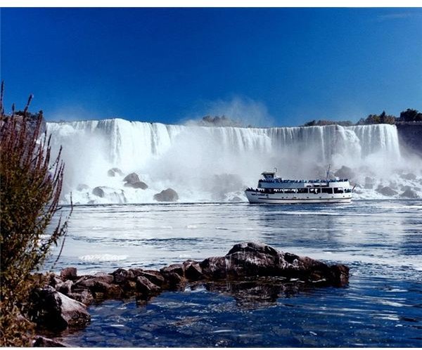
The Upper Great Gorge is closest to the falls. At nearly 365 meters, or 1200 feet, it is the home of the world famous Maid of the Mist ship, that navigates the waters to give visitors a closer look at the explosive Niagara Falls.
The Whirlpool Rapid Gorge area combines the river and gorge creations together, whisking water into a 90 degree turn and a drop in elevation of over 50 feet in a distance that is but a little over a mile. The mixture of the sudden curvature and drop in elevation create a section known as the Whirlpool Rapids. The Whirlpool Jet Boat does the only water navigation in this section of deadly water. Due to the power of the jet boat, it is the only water vehicle strong enough to power itself back out of the whirlpool.
The Niagara Gorge is home to the Lower Great Gorge as well. Lower Great Gorge may be the name, but the nickname fits it better. It is called the “Devil’s Hole” and was given the name because of a drop in elevation of about 16 feet in one spot. The Lower Great Gorge section of river is only about a third of a mile in length and drops a full 50 feet.
The Lower Great Gorge is about 250 feet wide in this section. The falls were split into two sections for a period of time when there was restricted water flow to the river itself. The river remained as two until the water of Lake Erie began to flow into the Niagara River again. Devil’s Hole rapids are categorized as class 3 rapids and are located in this section.
The oldest part of the Gorge is the Old Narrow Gorge. Niagara Falls started at this location. The Old Narrow Gorge is located in the Queenston-Lewiston area where portions of the gorge begin and were formed nearly 12,000 years ago as the falls developed.
Visitors can read a placard in Queenston, marking the line where the falls began. After years of traveling, the falls and river have flowed through the rocky area, where the gorge and various other falls have been created by nature through erosion. Visitors here can get an image of how far the water has traveled and how much the land formations have changed during these years.
Housing a rough part of the water flow, the Old Narrow Gorge is traveled by some personal watercraft but can be a dangerous undertaking. The Niagara River has an increase of water flow in the area from the power station discharge; however, this also creates one of the most spectacular views of the gorge.
The Lewiston Branch Gorge section extends from the Queenston-Lewiston area and into the Lake Ontario area. This is where most distinguishable features of the gorge end, as the travel leads into a drop of 5 feet in elevation, from the Devil’s Hole Rapids to the lake itself. The relatively calm water is a recreation site for boaters and kayakers to participate in their love of water sports, safely.
Sources
Media Centre; Niagara Falls Geology - Facts and Figures; Niagara Parks; https://www.niagaraparks.com/media/geology-facts-figures.html
Niagara Gorge Background; American Whitewater; https://www.americanwhitewater.org/content/River/detail/id/1360/
Facts About Niagara Falls; https://www.niagarafallslive.com/facts _about_niagara_falls.htm
Whirlpool Jet boat Tours; https://www.whirlpooljet.com/
Images
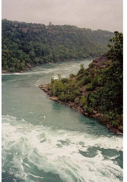
Lund, Ken; “Near the Whirlpool, Niagara River”, creative commons share alike generic license; https://commons.wikimedia.org/wiki/File:Near _the_Whirlpool,_Niagara_Gorge.jpg
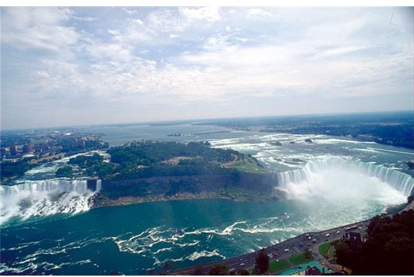
Huebi, Doc; “Niagara Falls view from Skylon Tower”; June, 9, 2004; GNU Free Documentation License; https://commons.wikimedia.org/wiki/File:Niagara _Faelle_Luftaufnahme.jpg
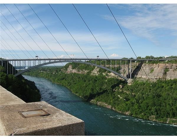
Atwater480; “Lewiston-Queenston Bridge is an arch bridge that crosses the Niagara River Gorge just south of the Niagara escarpment.”; June 13, 2009; creative commons attribution share-alike 2.0 generic license; https://commons.wikimedia.org/wiki/File:Lewiston-Queenston _bridge_01.jpg
Author unknown, level adjustments by Howching; “Maid of the Mist tour boat, Niagara Falls”; released to public domain; https://commons.wikimedia.org/wiki/File:Maid _of_the_Mist.jpg
Author unknown, “webcam view of American and Hilton Hotel Niagara Falls”, Niagara Live.com; Hilton Fallsview Hotel, https://www.niagarafallslive.com/Niagara _Falls_Webcam.htm and American Falls View, https://www.niagarafallslive.com/american _falls_live_webcam.htm