Understanding GBAS: Ground Based Augmentation Systems
Introduction
Augmentation or improvement of a global navigation satellite system (GNSS) position readings can be done if one is able to estimate the quantum of error. This is accomplished through augmentation systems. This is a method of improving the navigation system’s accuracy by supplying this estimate of errors to your GPS/GLONASS receivers. The type of augmentation system is classified by how the error estimates are fed to the receivers. One set of systems use the communication satellites to distribute this information.
Ground based augmentation systems or GBASs are a type of wide area augmentation system. Typically, the position information you can derive by your receiver, by looking at multiple GPS satellites, are in the range of about 15 meters. However, there are lot of applications that need better accuracies than that. Surveys need accuracy in the range of 10 cms. Airplanes need to have better than 15 meter accuracies in the vertical and horizontal directions. The category 1 or the Cat1 airplane approach capability for landing requires accuracy of 4 meters or about 13 ft in the vertical direction. Ability to use GPS simplifies the navigation needs of plane if the accuracy of readings could be improved.
The Basic Idea
To help improve the accuracy, it is important to know the amount of error that is happening in the GPS readings. If you have stations whose positions on the ground are known very accurately, then one can read position data of the same point from the GPS sightings and find out the error compared to the known good position data. If this error data can be conveyed to the aircraft GPS receivers and the receivers can correct the position data then you have better accuracy. A satellite’s positioning accuracy is impeded by errors in its clock and signal delays caused by atmospheric conditions. Also called a differential GPS (DGPS), an augmentation system compensates for those discrepancies by transmitting corrections to the GPS receivers either via satellite or terrestrial radio.
As per the ICAO (International Civil Aviation Organization) standards, the augmentation systems must transmit a specific message format and frequency which matches the design of the United States’ wide area augmentation system. Instead of the normal GPS accuracy, which is approximately 15 to 70 feet, augmented systems pinpoint a location within a range of two to 10 feet, depending on the system, and as little as four inches in the case of commercial systems.
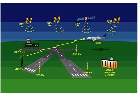
An Example of GBAS
The augmentation information is supplied to the aircraft as shown in the figure from the terrestrial radio below. The two GPS receivers gather the local position data and compare with the actual position. The international civil aviation organization mandates that the messages broadcast over the GBAS be in the FAA’a WAAS format. Read this article here for a detailed discussion on GBAS and their safety aspects.