How Does Google Maps Work? Google Explained
How Does Google Maps Work?
Google Maps is the groundbreaking free to use map service from Google that features satellite photos of most of the populated areas on Earth. Combined with different views (for instance you can swap the satellite photo for a straightforward map) and various other Google technologies, Google Maps has become a popular destination for anyone looking for directions to a town, hotel or address, as well as anyone wishing to find out which neighbours have swimming pools.
The best thing about Google Maps is that it is free – given the amount of work that has gone into mapping the satellite images with a vast database of locations, conversion of satellite photos into map illustrations and the various extended functions provided by Google and other websites via the API, this is quite remarkable.
But how does Google Maps work?
Satellites and Databases
Google Maps combines images with a huge searchable database of locations.
**
Satellite Data
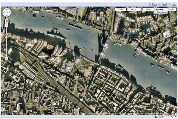
Information found on Google Maps is collated from a selection of databases – but key to it all is a collection of satellite images of cities across the globe. In some cases the images are a touch out of date and don’t show new building developments, but on the whole they perfectly illustrate the world around us.
Database of Locations
Once the data from the satellites has been captured and converted into small image files, they are cross referenced with a vast database of map references.
These map references (typical longitude and latitude co-ordinates) have already been matched to countries, city names, locations, addresses and postal codes, and utilizing their skill at creating search engines, Google have created the most popular online database of real world, physical data.
Google Maps Has Changed the Way We Search
Not only can you search Google to find an address and telephone number for your local GP surgery, you can also view the location of the surgery on Google Maps.
If you have a Google account, you can setup Google Maps to always start at your address – this is useful if you want to narrow down search results for your area. Search performed in this way feature results that are tailored for your location, and you can search further afield by naming a city in the search, such as “doctors, Manchester”.
One of the creators of Google Maps is Lars Rasmussen – he once described the service as “a way of organizing the world’s information geographically.”
Given the number of ways it can be used, Google Maps is certainly fulfilling that aim.
Google Maps Mashups
Along with the basic search function that will display the country, city, business or address you have entered, Google Maps also provides a directions service that can be used to build a travel itinerary, as well as the infamous Google Street View.
This last function of Google Maps has caused some controversy among people concerned about their privacy – Street View mixes rotoscopic images of various towns and cities across North America, Europe and Australia and parts of Asia with their locations on Google Maps, giving the viewer the chance to see what the location looks like.
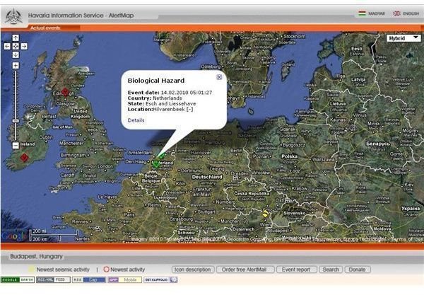
If you’ve ever wondered “how does Google Maps work with other services?” (such as appearing on websites of small businesses to show their location) this is thanks to the Google Maps API (application programming interface) a relatively simple to use method of working with the Google Maps data. Many of these exciting new “mashup” services use this API, such as AlertMap (hisz.rsoe.hu) which combines Google Maps with data showing severe weather, seismic data and biohazard threats.