What is a Warm Front and Cold Front and the Differences Between Them
A weather front is best described as a boundary that separates two different air masses that have different densities, and it is the main cause of meteorological phenomena. After a weather front passes, the weather it produces tends to clear quickly. All fronts produce wind shift invariability, however, not all will produce precipitation, and some produce just little cloudiness.
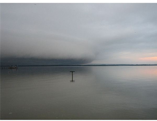
Cold Fronts
So, what is a cold front? This type of weather front is found at a temperature drop’s leading edge. It is found at the isotherm gradient’s leading edge in an isotherm analysis, and is typically found in a sharp surface trough. Cold air is far denser than warm air and cold air quickly replaces the warm air leading the boundary, therefore, cold fronts produce sharper weather changes and moves up twice as fast as warm fronts. These fronts occur along with a low pressure area.
Warm Fronts
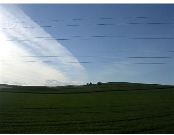
So, what is a warm front? This type of weather front is found at a homogenous warm air mass’s leading edge. It is found at the isotherm gradient’s equatoward edge, and is typically found in a broader trough of low pressure. This type of front moves far slower than cold fronts do. This also results in the temperature differences across, or throughout a warm front to be broader overall, in scale. As the front approaches, rainfall gradually increases, and the clouds preceding the warm front are most often stratiform. Preceding a warm frontal passage, fog can also occur. After a frontal passage, warming and clearing is typically rapid. Thunderstorms can be deposited amidst stratiform clouds preceding the front, and the thundershowers can continue after the frontal passage, if the mass of warm air is unstable.
What is the Difference Between a Cold Front and a Warm Front?
The key difference between cold fronts and warm fronts is how they are created. Of course, a cold front is associated with colder weather and a warm front is associated with warmer weather. Also, the isotherm gradient’s edges and troughs have differences (both discussed above). The primary differences include:
- Warm fronts occur when cold fronts are crashed into by a warm air mass, causing it to rise.
- Cold fronts occur when warm fronts and cold fronts collide, and driven upward.
Both warm fronts and cold fronts clash, but they never mix. They drive each other up.
What is an Isotherm Gradient?
Isotherms are defined as the lines on a weather map that connect the points of equal temperature. So, the temperature values are the same at each point along a given isotherm. They are created from simultaneous, regularly scheduled temperature readings at different locations. The process of constructing a map of isotherms is referred to as contouring, and it is a rudimentary step in temperature data analysis.
What Type of Weather is Associated with a Cold Front?
As a cold front approaches, atmospheric pressure drops. As this weather front passes, the winds that are present will shift from south to southwest, and eventually they will begin to blow in a westerly direction. Due to the air masses contrasting greatly on each side of the front, it is very possible for violent, unstable weather conditions to form. Intense downpours that tend to last for a short time are common due to towering cumulonumbus clouds. Being ahead of an approaching cold front can create one of the most extreme weather conditions to form, known as tornadoes.
What Type of Weather is Associated with a Warm Front?
As a warm front approaches, atmospheric pressure drops. The gentle uplift associated with warm fronts makes it possible for a sequence of clouds to form. Cirrus clouds are the first to appear, followed by stratus clouds, as the warm front nearly centers on a location. The wind will come from an easterly direction ahead of the front, and will be generally cool. Low intensity precipitation, due to the nimbostratus clouds along the front, often occur, with the precipitation having the potential to be long-lasting. The wind will switch to a southeast and south direction as the front passes, and as this weather front passes, the warm air will will begin to replace the cool air, resulting in the temperature beginning to rise. The air pressure will also increase with the temperature, and the skies will begin to clear as the stratus clouds begin to give way. The humidity in the air will also increase.
Resources
Utah State Office of Education. (2001). Weather Fronts. Retrieved on August 14, 2010 from the Utah State Office of Education: https://www.schools.utah.gov/curr/science/core/4th/4thsciber/weather/html/fronts.htm
WeatherQuestions.com. (2007). What are Cold Fronts and Warm Fronts? Retrieved on August 13, 2010 from WeatherQuestions.com: https://www.weatherquestions.com/What_are_fronts.htm
National Oceanic and Atmospheric Administration’s National Weather Service. (2010). National Maps. Retrieved on August 14, 2010 from the NOAS NWS: https://www.nws.noaa.gov/outlook_tab.php
Image Credits
Cold Front: Fawcett5 – Wikimedia Commons
Warm Front: Val Vannet – Wikimedia Commons