Understanding the Electronic Navigational Chart (ENC)
Electronic Navigational Chart
An electronic navigational chart, or ENC, is the digital form of a marine navigational chart that is published to aid ships to navigate through international waters. It is, in essence, a database of information essential to safely navigating major bodies of water. All of these charts are published and conform to International Hydrographic Organization, or IHO, standards. The use of an ENC makes ship navigation easier and faster, and effectively safer. Here are more information about this chart.
Use of Electronic Navigational Charts
Electronic navigational charts give a ship’s navigation system the correct information that allows it to navigate waters safely and in a fast manner. The essential information include the positions of ships, dangerous areas that allow for early warnings to navigators and extensive map and radar images. Using digital charts makes it easier for navigators to have access to all kinds of information. Because it is digital, it can be enlarged or made smaller, displaying important information to the navigator in a very convenient way and as they see fit. Navigators can skip using paper charts if the digital charts they have comply to vector format standards set for ENCs.
Accuracy
How accurate are digital charts? Well, most digital charts are only as accurate as paper charts that are their actual source of information. Information about land masses are usually incomplete, so digital charts actually have less information about maps. Enlarging the digital chart too much may also cause it to look less precise. Right now, using digital charts is just a way of viewing paper charts in a digital manner with no added accuracy or precision. Nevertheless, more information can be added to digital charts that are based on paper charts to make it more useful and more accurate.
Reminders to Navigators
For some areas, especially isolated shallow areas, information about depth may not be reliable if the digital chart is viewed in standard mode. This means all available layers for the chart should be used when reviewing and plotting the course for the ship before it takes to the seas. The route planned by navigators should be based on all available information so safety can be ensured. Navigation systems in ships can plot routes automatically, but this should not be relied upon on an exclusive manner. Manual plotting of the course is still best whether one is using paper charts or digital charts.
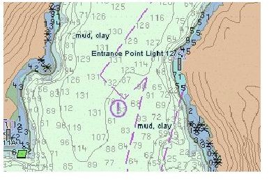
Elements of an Electronic Navigational Chart
Areas that determine coastal and harbor locations as well as those that dictate the approach of the ship towards land are indicated on the chart using a color coded legend. Of course, names of land masses and bodies of water are also indicated. This information is available in the standard mode of viewing digital charts. Other information like water depth and sailing directions are available in layers that can be applied to the standard view of the chart. The information in an electronic navigational chart contains standardized elements such as structure and format, ensuring that digital navigation complies to one ruling body, which is, in this case, the IHO.
Photo Courtesy of Wikimedia Commons